This is a long post photo-wise as there was just so much to see on these 2 days in Nevada's Great Basin National Park that I thought it would be better (and faster) to do captions on each, and if there was anything of note to add that in not-so-bold lettering. So here goes -- what I saw on July 11 in chronological order --
This Pronghorn crossed the highway in front of me. I fumbled for my 100-400 lens on the passenger seat, got the strap tangled, uttered an oath, and finally got this somewhat butt shot. And it has quite a rear end...
A Horse With No Name -- "Skeletal Art" along the entrance road to Great Basin Nat'l Park. The roadside was dotted with whimsical metal art.
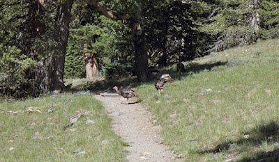
On the trail to Stella and Theresa Lakes -- Why does the Wild Turkey cross the trail? I was surprised to see these at 10, 100 feet.
A deer poses picturesquely against a background of towering trees and the Wheeler Peak complex.
Stella Lake -- yup, Nevada has more than sagebrush, casinos and cathouses.
An inlet creek to Theresa Lake is dotted with Parry Primrose (thanks to my friend Romain Babcock for the flower ID).
Theresa Lake, about a mile's walk from Theresa Lake. I took this hike in the morning; the afternoon was so windy the visibility in the neighboring valleys was nearly zero. Serendipitous once again in doing the hike when I did.
In honor of the 4 Tenors -- ok, 3. 4 juvenile Barn Swallows waiting for their parents to give them yet another round of nosh. The nest was on the BLM campground's bathroom building -- right above the bathroom doors. Appropriate, I guess, as there were droppings below the nest. Fun to watch!
July 11, at the start of my hike up to Wheeler Peak. I was the only one there that early in the morning, but I met about 20 others while going up and down the trail.

Ummm, uhhh...OK, I've been warned. But I've done this hike before -- more than 10 years ago. And I've done the option hikes already.
Come ON, what is it with these Turkeys?
The trail goes across a low saddle, where the winds can be fierce. I hear from other hikers the wind was blowing like the dickens the day before. So far it's windless today.

Well, it doesn't look TOO bad...My destination, the top of Wheeler Peak, about 3000 feet above the trailhead.
The wildflowers are awesome and colorful, and are even on top of Wheeler Peak. Butterflies, bees and moths, too.
Here's a sign of how the wind can howl through here -- protection from the wind made out of rocks. There were about 3 such wind protectors along the trail.
Ma, are we there yet? Nope, the summit is behind that. At this point, the rocks make the walking a bit unstable. And it's steep, too. It's even worse going back down.
It was at about this point that I met a fellow going back down the trail. "There's no wind up there! By the way, my name is --- " (I forgot, Eric something, from Davis, CA). "My name's Steve Wolfe". "What, THE Steve Wolfe? It's an honor to meet you on the trail! I've seen your photos on Smugmug and the Internet!" OK, that could be me... Until he said "So are you still doing presentations and seminars? Still conducting classes out in the field?" Uhh.....I lied, and kept up the deception. "Sure!" I realized at that point he got me mixed up with the other Wolfe -- Art. Oh well, he swelled my ego for a few minutes...
Top of the world, Ma! Wheeler Peak's summit, at 13,065 feet. It's the second tallest mountain in Nevada ; Boundary Peak in the White Mountains just inside the border on the west with California is the tallest -- 13,146 feet. On this day you can see for about a hundred miles in all directions; this is looking east. The day before, with all the wind, you couldn't see anything -- but you wouldn't want to climb to the top, anyway.
Here's the US Geological Survey marker on Wheeler Peak's summit. 1944, "Fine or imprisonment for disturbing this mark". How did they know I was planning on prying it off?
I'd like to see the little UPS truck drive up the trail to deliver mail HERE...There's a register inside. I signed it with my name, Portal, AZ, and a comment -- "Spectacular!" (Sorry, not too original. I couldn't think straight because my brain was oxygen-deprived.)
From the summit, here's the view looking southwest at the Spring Valley. Nevada is the most mountainous state in the lower 48 -- over 200. They trend north to south; someone described them as looking like caterpillars on the map, crawling down it. Nevada has been called "the poor man's Alaska". It's part of the Great Basin, where its lakes and streams don't flow to a sea; they end up in one of the valleys between the mountains. Valley and mountains -- Basin and Range.
Here's the view looking to the north. The low area between the mountains is Sacramento Pass, between the Snake Range. The bald-topped mountain that you can barely make out on the northern range is Mount Moriah; I hiked up to the top of Moriah about 10 years ago. Beyond that, you can see the Deep Creek Range. If you want to be away from everyone, that's the range to visit. I never have -- yet.
Even at the top, 13,000 feet, the wildflowers are gorgeous. They help to keep your mind off the sheer drop-offs around you. I know I have a touch of vertigo...
As I mentioned, coming back down is the REAL bear. A steep gradient, loose rocks, scree and talus -- it tested my limits. But the views somewhat kept my mind off the steep descent. Here's looking to the east, with a half moon above the mountain. (One of the peaks in the Wheeler complex is named Jeff Davis Peak, after the Confederate president. Southern sympathizers were very prominent here during the latter part of the 19th century.
Here's looking northwest to the Spring Valley. On the western edge of the valley is the Schell Range, also very picturesque, especially in fall. And those durned rocks on the trail...
Ah...relief! The trail smooths out, and it's now nearly level. That's Stella Lake below. Thankfully, there has been very little wind during the hike -- and yes, Eric was right, it was windless on the summit.
Here's looking back up the trail; the curved helmet-like peak is Wheeler, where I'd been on top just a few hours before.
Wildflowers continue to dazzle with their color.
Ah, back at the my campsite at the Sacramento Pass, about 17 miles west of Great Basin Nat'l Park. Along with the resident Barn Swallow family are Mr and Mrs Kildeer; here one of them does the "broken wing" routine, which is supposed to distract predators away from its nest. They're living in the small riparian area at the campground.
It's now the morning of July 12, and I'm heading for my next stop -- northern Arizona's town of Elko, and the spectacular Ruby Mountains, called "The Swiss Alps of Nevada".
I finally got a good photo of a jackrabbit!
Here are two
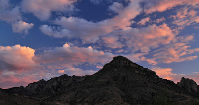
And a final sunset from my campground site at Sacramento Pass. Barely visible at the bottom is Notch Peak, in western Utah's House Range.


