Monday, January 11, 2016

A Walk Around Overton, Nevada

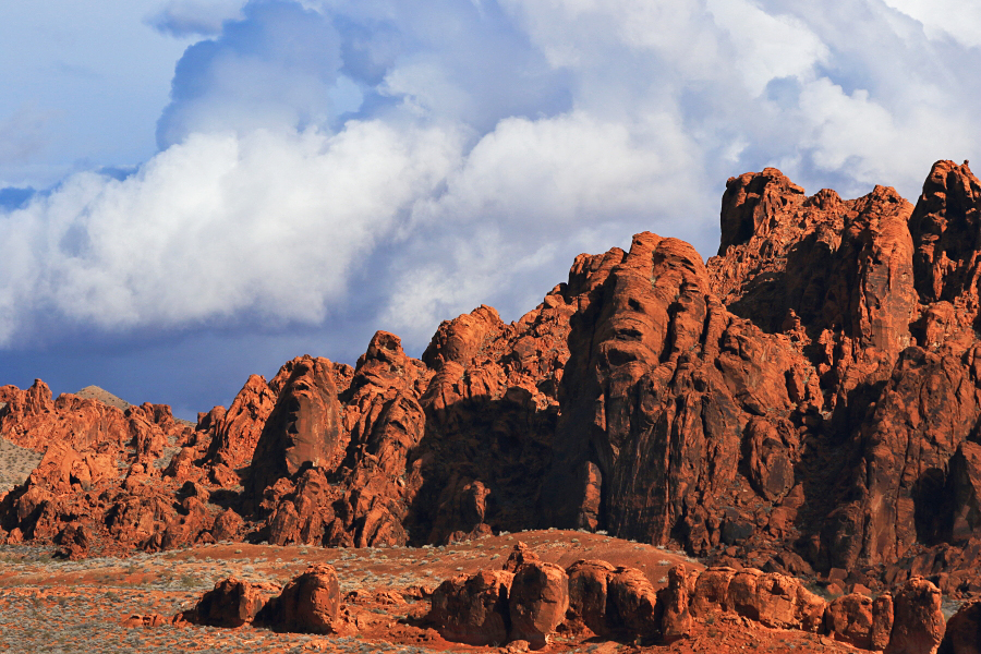
I've been mentioning Overton in quite a few of my blog posts, since I've been wintering here for the past 3 years, so I think it's time I devote a post to telling you a bit about it... Some history first. Overton is located in Clark County, Nevada, about 65 miles NE of Las Vegas (aka Lost Wages), and on the north end of Lake Mead. It was originally settled in 1869 by the Mormons, and it's still very much a Mormon town. Over the years, Overton developed as the main business center in the lower Moapa Valley. In the 1930's, the town of St. Thomas was inundated by the rising waters of Lake Mead as it was being filled, so the majority of its population moved to Overton. (St. Thomas can be seen once again, now that the Lake Mead has receded over the years, though it's just the foundations of the town's buildings, and bits and pieces of glass and things left after it was submerged; still, it's a good example of "urban" archaeology.) There's a silica plant here, silica being used mainly for making glass, 4 "eateries" in Overton -- The Inside Scoop (Blue Bunny ice cream and good homemade sandwiches, among other things) Sugar's, Carley's, and a MacDonald's  (and one more in Logandale, Tiffany's Subs and Pies -- and let's not forget the shaved ice), but the number of places to grab a bite sometimes fluctuates -- the Chinese restaurant between Logandale and Overton closed, for example; one bank, one grocery chain store (Lin's), a Dollar store, 2 hardware stores, a Napa auto parts, a post office, gas station, and various other small businesses;  basically one of everything that makes up a small town. It's the closest settlement to the spectacular Valley of Fire, but is surrounded by lots of eye-candy landscapes. Now that I described it in words, let's take a visual tour -- 

Here's the "main drag" looking north -- Moapa Valley Blvd, which is Highway 169 that runs through the lower Moapa Valley, the towns of Logandale (best known for its Pomegranate Festival in late autumn) and eventually to Lake Mead. The thrift store is a good place to find bargains on household goods. I'd left my pots and pans at Faranuf, so I bought an emergency pot and lid from them for 75 cents. 


Looking from the other side of the boulevard, there's Lin's, and behind that Mickey D's, which on some mornings seems to be the social center for snowbirders staying in the 2 RVparks here. I myself use the drive-thru on occasion for a quick breakfast -- fruit and maple oatmeal and the 2 sausage burrito meal -- when I'm heading somewhere for the day and don't have the time to make breakfast. The Red Rooster Bar is across the street, and just above that is Sugar's, one of the main, and best known restaurants in the lower Moapa Valley. And this is pretty much the amount of traffic on Moapa Valley Boulevard during rush hour. What a difference from the jam-packed 91 freeway through downtown Riverside...


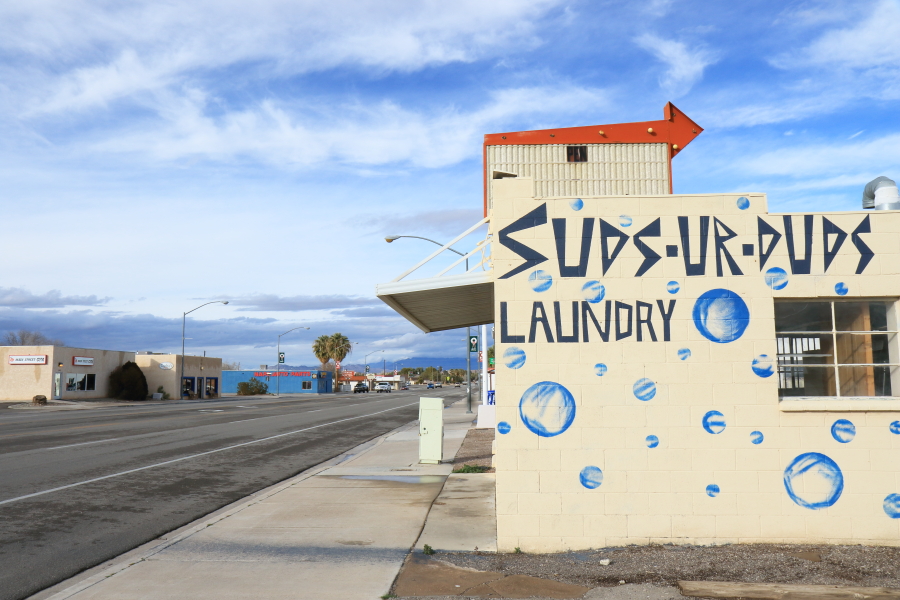
Suds-ur-Duds. I used it on occasion as it had oversized washing machines, but alas it closed. David Anderson, new FB friend and Overton resident, said the building used to be Overton's post office, and his dad's cousin was the postmaster.


Here's the one gas station in Overton ( and there's a Chevron station up in Logandale, too) -- Maverick. My one question is -- what's a Chorcheezo? Hmmm, I may not want to find out...


The pinkish building in the pic below is the post office. And the tire tracks in the mud, that lead to the post office's paved parking lot, made me wonder, why go through all that mud when you could do like that truck on the right -- go from paved road to paved parking lot to get your mail?  Yahoo!  Muddy truck time!

It sounds like quite a few folks here used to work at the next establishment when they were younger -- the local movie house. When I did a briefer Overton overview post on my Facebook page, people responded with reminisces about working there -- running the projectors, and in once instance saying her parents owned it. And this same Overton resident, Diana Peterson, said one of its previous names was the El Notrevo -- which is Overton spelled backwards. Alas, like Suds ur Duds it's been closed for a few years now.

o

There's a house facing  Moapa Valley Blvd that has this sign on the street sign post; it reads "Private Property -- Trespassers will be violated, survivors will be shot". And I get the feeling that it's all true...

Here's Sugar's Home Plate Restaurant and Sports Memorabilia, a local landmark. It's owned by Ray and Judy Metz and is named for Ray's nickname (as in Sugar Ray Robinson; most of these facts are from Nevada Magazine's spotlight on Sugar's, from 1998). It opened in 1991, and as its name says has a collection of sports memorabilia. The Los Angeles sports figures on the front are of Sandy Koufax, the one next to the front door is #13, a quarterback of the Rams when they were still in LA (I looked up the number on the Internet, which says it's Jeff Kemp)... and I forget who's the one in the middle; forgive me, folks...


And I know I've left out many other businesses; once again my apologies, Overton residents. So even though it's not a beautiful town visually, it's still a good example, along with Logandale, of small-town America -- and I love it here. Though the summers can get quite hot (so I've heard; I'm outta here by March at the latest). 

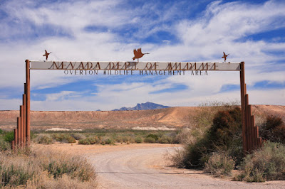
Just outside of town, to the south, are a few areas that I visit frequently. I've mentioned the Overton Wildlife Management area many times, as I frequently visit it for hiking and wildlife photography. And when I posted the following photo on my Facebook Overton post, a resident commented that his dad put the sign up. I think it's very distinctive -- and I like the way Virgin Peak, a landmark here in SE Nevada, is right in its center. 


Once inside the wildlife area, you can get agricultural fields, the mesa (Mormon Mesa, running along the east side of Moapa Valley) and snowy Virgin Peak -- all in the same view. 


So, that's a view of Overton, and the lower Moapa Valley. It's a small town full of friendly folks surrounded by spectacular scenery. And before I end this post -- I forgot to mention the Muddy River, which runs through the valley. It's the lifeblood of the area, but can be treacherous too -- witness the flood from August 2014 which devastated the area and wiped out part of Interstate 15. But the people here bounced back -- and the Moapa Valley and the towns of Logandale and Overton are definitely worth a visit . You can stay at the Northshore Inn just as you enter the town; I did, and walked across the street to La Fonda for great Mexican food... 


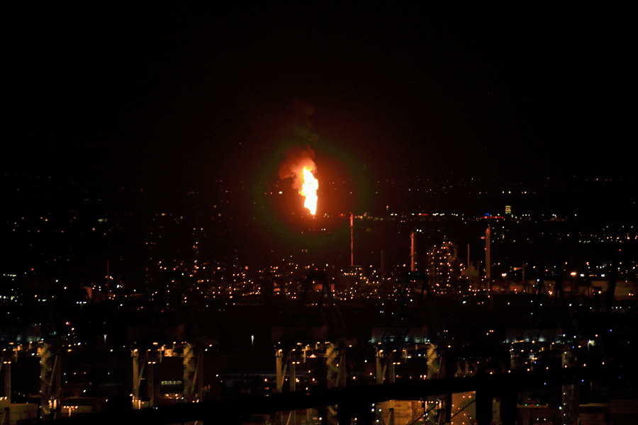
The "M" on the mesa is for Moapa. And I'll end this with a panoramic view of the silica plant on the right, looking as if it's lit up by a spotlight; the town of Overton to the left; the long ridge of Mormon Mesa; the Mormon Mountains to the left, behind the mesa; and the vast, turbulent, awesome sky over this part of SE Nevada. 


Sunday, January 10, 2016

January 6-8 -- The Valley of Fire

Rain is a pretty rare event here in SE Nevada. But with the current El Nino weather pattern, it's inevitable that we get some. And while it didn't rain too much down here in the Overton and the Moapa Valley, it rained a good deal up at the Valley of Fire, where it matters for photographers. Well, it did rain somewhat here in the valley; this is a photo of the RV park where I'm staying, the morning after the heaviest rain -- 


That's running water down the center of the road. It looks worse than it was; it dried up later in the morning. But rain here meant rain up top, at the Valley of Fire -- and it didn't disappoint. In fact, I went to the VOF for the next 3 days, to take advantage not only of the water collecting in the depressions in the rock, but the snowy backgrounds; the snow level was down to around 3500 feet. On  the 6th, as I arrived at the east entrance of the park, the clouds were cloaking the mountains, but my attention was caught by this sign -- 


Literally a sign of the times. Was this a problem here, at a fairly remote park? A friend of mine saw this photo and said the park has jurisdiction over the land, while the FAA has control of the air space above, and this leads to some conflict and confusion as to who's responsible for the "friendly skies". Whoever is in charge, it really gets your attention as you enter the park. 

Let me backtrack for a moment. I actually took a short drive in the Lake Mead National Recreation Area and Northshore Road, which runs along the north shore of the "lake". It's a favorite drive of mine, with its multicolored hills and desert vistas. Here's a view looking across Lake Mead, which you can see at the bottom. It's still raining, but the sun is breaking through the clouds -- 


 On to the Valley of Fire. This is actually going to be a combination of the 3 days at the park, January 6 through 8, as I covered basically the same areas each time (and its a relatively small park). First it's out along the road west leading to the campground. These clouds caught my eye looking north --


Like cotton candy, or cotton balls pulled apart. (And when I posted this on Facebook, someone mentioned seeing a face in the rock on the right; it's looking up, somewhat like an Easter Island statue -- and they're right. Lots of human and animal forms can be seen in the rocks here.) On the loop road near the campground, there's a somewhat famous landmark called Piano Rock --


With 2 legs, it's like a massive Steinway. Back past the visitor center, I look across to the area of Piano Rock in the distance -- 


The rains were on the 5th thru 7th. On the 8th, a rare event happened -- the White Domes Scenic Byway, leading to the north end of the park, was closed. The ranger said mud had covered the roadway, so it was being cleaned up and scheduled to re-open in a hour or so. Still, I had to take a photo as it's something you don't see here too often. 


I had some time to kill, so I looked for a particular image in the rock near the visitor center. If you look closely and know your iconic images of the 20th century, you may recognize this one -- 


It's been called a redrock version of Edvard Munch's painting "The Scream" (yes, this was before that kid clapped his hands to his face in "Home Alone"). With just a little imagination, you can see hundreds of images in the Valley of Fire rocks.  A little later the road re-opened, and as I entered the narrow defile leading to the north end of the park, I could see what the ranger was talking about --


 It's still more dirt than road. And the tortured landscape makes it look like a scene for another planet. Once the landscape opened up, the areas of rain water were in the lower washes --


The low winter sun was illuminating the landscape, but the sky to the north still looked ominous. And I thought the sinuous road added interest to the overall scene -- 


There are 3 parking lots along the White Domes Byway. There are No Parking signs all along the sides of the road; you can only park in the lots as much of the road is narrow and twisty. From the lots, you can hike to your heart's content. I hiked west from parking lot #3; hiking east leads to the Fire Wave. To the west is more interesting. There's the massive monolith with its near-vertical face that somewhat reminds me of Half Dome -- 


Long ago, that rock face must've fallen right off, creating that jumble of rock at the bottom -- 


Here's an overall view of that area, looking northeast from atop a nearby hill -- 


There's a unique formation down there called Crazy Hill -- though many formations here can be called that -- 


It's striped, colorful rock that grows more intense depending on the angle of light and clouds. It wasn't too bad today -- and when I was there a lone hiker was on top of a nearby dome, silhouetted against the sky -- 


Here's looking up at that face of Crazy Hill -- 


This is near the area of "The Swoosh", where a pattern in the rock resembles the Nike logo. See that small "arch" on top of that rock near the center?


The Valley of Fire rewards you with many small details.. Here's looking east near the same location; the mountain wreathed in clouds is Virgin Peak, tallest in the Virgin Mountains -- 


This area is among the most colorful in the park -- 


Back out of the park and on the highway to Overton, you can get an even better view of Virgin Peak --- if you have a 100-400 lens, that is, which is what I used to take this photo -- 


As I mentioned earlier, the snow level was down to around 3500 feet, so it was a treat to see the desert mountains here dusted with snow; this is looking at the Gold Butte area, land of Falling Man, Little Finland and Khota Circus --


When I was going through the "boon docker's mesa" just south of Overton, a massive thunderstorm was forming to the northeast. It dwarfed the houses of Overton below it; the long mesa is called Mormon Mesa; Mormons were the original settlers here, and Overton is still a Mormon community -- 


It was an exciting 3 days packed with colorful landscapes tempestuous weather, and rarely seen snowy vistas. Tomorrow it's back to the wildlife management area here.. 

Friday, January 8, 2016

January 2-3 -- A Return To Overton, Nevada And A Visit To The Overton Wildlife Management Area

I REALY have to get back to doing my blog daily -- otherwise I'll forget what day I took the photos... :o) But the first one was from last year, when I stayed in Las Vegas (aka "Lost Wages", as that's what invariably happens there) attending a class to become a "wildlife technician" for state and federal agencies like Nevada's Department of Wildlife and the national parks system. I took the class -- then got out of the city as fast as I could. I prefer smaller towns and natural areas, not the go-go city. For 56 years I'd lived in a big city ( San Pedro, with 80,000 people) that was attached to even a bigger city (Los Angeles), and I was ready for a change.  So I didn't see Viva Las Vegas, much less change my name, get a tattoo, and make myself over as "Mario" at the Wedding Chapel (much less be partnered with "Alaska" with dyed red hair).


I can see the Lost Wages' allure --- but it's not for me. So on New Year's Day, 2016, I blast my way through the city on Interstate 15 (not before seeing a billboard advertising "Bugsy Siegel Windows
and Blinds", with the tag "We'll Kill For Your Business") and not stop until I reach the turnoff for Highway 93, the route north to Great Basin Nat'l Park. Then it's on to Overton, and the RV park
where my trailer, "Discovery II", waits. I'll be posting an overview, along with a brief history, of
Overton in the next blog entry. For right, now all I'll say is it's a great little town in a beautiful setting, surrounded by the Valley of Fire, Lake Mead, and Gold Butte. But right now my focus is on the trailer. Here it is at the the RV park, in a photo taken a few days later after it rained -- 


It's a 2015 Lance 1685 travel trailer, 20 feet long, with 2 solar panels on top; those will be great for any future boondocking (staying in an area with no facilities). I check the trailer, and it seems to have weathered its 8-month stay at the RV park better than I'd expected. And the good thing about now having a house is I won't have to cram all of my worldly belongings into my trailer. After buying it, I discovered that it had less storage space than my previous Lance trailer, Discovery I. It bothered me at the time as I had to carry some of my things in the back of the truck -- but now I'm not worried. I'll just take the excess stuff back to Faranuf, and only carry what I need for, say, the week-long trips I'll be using "her" (Tundra is a "he",  Discovery is a "she") for from now on. So I get settled in, and the next day head over to one of my favorite spots here, the Overton Wildlife Management Area -- 


I just found out (January 7), through a Facebook photo post I did on Overton, that one of my FB correspondent's father put that sign up. The wonders of Facebook...The OWMA, as it's known, is an amazing area of 16,000-plus acres (its size depends on the level of Lake Mead, which it's connected to) of, depending on the day you go, literally anything in terms of wildlife -- or literally nothing. Today is a literally anything day -- especially for raptors. Like this Mrs. Northern Harrier -- 


And I saw this Merlin right from the get-go -- 


A Marsh Wren was doing its "liquid-y" call -- 


American Pipits were in the agricultural fields -- 


Here's another raptor -- a sub-adult Red-shouldered Hawk. I originally thought he might be a Red-tail, but his breast plumage makes him an RSH -- 


And this one. Before I investigated the swan for its ID, I thought it might be a rare Trumpeter Swan; they've been seen here in past winters. And if not a Trumpeter, perhaps a Tundra. But the bill is different than a Trumpeter's; this one is curved, while the Trumpeter's is runs straight from the forehead to the tip of the bill. And this Swan's bill is bi-colored; both Trumpeter and Tundra is not. So -- what is it? Alas, only a Mute Swan, an invasive species that was brought in from Europe to "decorate" lawns and parks in the East, and have since spread. During my investigation as to ID, I find out that there is a colony of Mutes in the St. George area, about 70 miles to the east, so it probably had flown here from there.  Still an interesting find, and I had a good lesson in Swans --


More on the town of Overton, and visits to the nearby Valley of Fire, coming up in my next blog post... 


Tuesday, January 5, 2016

January 1 -- Los Angeles, Both Compelling And Hellish -- And Birds At Terranea

I'm now in Overton, Nevada. When I mention Overton most people say "where?" and even when I tell them it's on a northern arm of "Lake" Mead (I put that in quotes as it's a reservoir)  they still scratch their heads. I'll be in Overton for the month of January, so I'll describe it and the surrounding areas as time goes on. But first, a summation of my 2-week visit to the South Bay section of Los Angeles. I stayed with my father who has a condo with a great view of the LA basin. It's literally a city of millions -- millions of people, millions of lights at nighttime, and millions of cars. Portal, the San Simon Valley, and the Chiricahuas where I now live is almost the exact opposite -- 600 people at most within a 15-mile radius, very few lights at night (no street lights, no sidewalks, very few house lights as there are few houses) and what cars there are, are mostly trucks, with cowboy hats and a rifle rack or two inside. (OK, perhaps I'm exaggerating a little for effect, but a lot of rural ranching and farming goes on there.) Admittedly, LaLaLand can have a bewitching beauty, particularly the downtime skyline at night; here it's reflecting the last light from the sun, as the city lights go on --


But there is, of course, a darker look to Los Angeles. The next photo was taken from my dad's balcony; the condo is in San Pedro, otherwise known as the Port of Los Angeles, a somewhat gritty area of docks, container ships, and refineries. Here's one of those oil refineries. It's burning off gas, but with the flame and refinery lights it looks somewhat, well, demonic -- or a futuristic scene out of "Blade Runner". Which, ironically enough, was set in a Los Angeles just a few years from now -- 


But even in this science fiction landscape, there can be a bit of poetry -- 


But San Pedro, and the Palos Verdes Peninsula adjacent to it, is not all like that. The peninsula used to be an island, and is more related geologically to Catalina Island, 26 miles away, than to the mainland, to which it's now attached. Here's looking northwest up the rugged shoreline ; the green on the right is part of Donald Trump's golf course; I shall refrain from any snide remarks about who just might be our next president, Lord help us -- 


That photo was taken with my 17-55 f/2.8 landscape lens. I used my 500 f/4 lens for the next one; it's the last "arm" of the peninsula seen in the above photo. The buildings are part of Terranea resort, which was built on the former site of Marineland of the Pacific -- the SeaWorld of its day. Now it's a posh hotel, along with  million-dollar homes --


And, surprisingly, there are a lot of "good" birds to  be found on the grounds of the resort. Part of the deal to building Terranea was to rehabilitate the surrounding area with native shrubs and plants, and that has attracted birds that haven't been seen there in years. But now they're thriving... Here are 2 Savannah Sparrows -- 


And the REAL success story has been the return of the California Gnatcatcher. It had pretty much disappeared from the area after its habitat had been destroyed, but now that the native flora has for the most part returned, the Cal Gnatcatcher is back. I visited Terranea 2 days straight and saw about 10 in the sagebrush -- 

That's one going grabbing hold of the wing of an insect on the ground. Their song, though hard to hear, sounds like the mewing of kittens. Further on down, near the shoreline, is Nelson's, a swank restaurant, but I wasn't interest in that; there were "red hot poker" plants nearby, which was attracting birds; here's a Say's Phoebe -- 


An Orange-crowned Warbler in a very complimentary setting --


And the hummingbirds.. Surprisingly, this is a great place to photograph them. The sun is at your back in the early morning, and they're going for the nectar in the blooming red hot poker plants; 
here's a juvenile Anna's male -- 


And an adult Mr. Anna's; only the male hummingbirds have the gorget which, with the sun at the right angle, shines with color -- 


And sometimes you get lucky... I took about 50 shots of this juvenile Allen's hummingbird, and in this one shot I got it extending its tongue -- 


And here's the adult male Allen's, complete with iridescent gorget color -- 


So San Pedro, the Palos Verdes Peninsula, indeed areas in Los Angeles, has its wild, or half-tamed, areas -- Averill Park (Townsend's Warblers, and visiting Green Heron, Mandarin Duck, Snowy Egret, and Belted Kingfisher); Eastview Park  behind a Coco's restaurant (Western Bluebird, and a group of us discovered a White-throated Sparrow there, which is uncommon for the area); Terranea; the South Coast Botanic Garden (a migrant trap which has seen 2 Mississippi Kites and Thick-billed Kingbird in recent years, among others); Point Fermin with its 2 resident Peregrine Falcons; and many other oases in a sprawling urban setting. It's a great reminder that nature is all around us -- if we can only SEE it. But now it's time to say goodbye to LaLaLand, and on to Overton, Nevada, to be reunited with my travel trailer Discovery II...