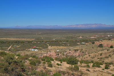
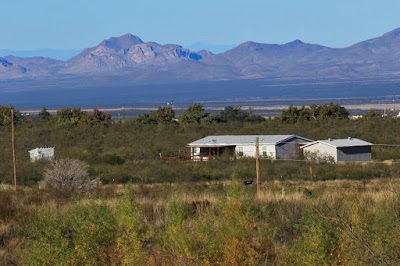
And Portal Peak and the rock formations below it. I was going on a day hike in that area today...
There's a loop trail in the rolling hills just east of the mountain, which you can see in the above photo. It's about 6 miles, with an elevation gain of around 1,000 feet, so I figured it should be much easier than the 3,000-foot climb in 4 and 1/2 miles to the top of Silver Peak. The only difference was -- this time I was going solo. Yes, I know all the hazards of doing a hike alone -- but I'd done many in the Chiricahuas before, and I've done multi-day backpacks in the eastern Sierra which were REALLY tough hikes -- try a 6,000-foot climb in about 8 miles with a 40-pound backpack.. So I was figuring this hike should be easy-peasy. The parking for the trailhead is only about a mile from Faranuf -- sure, I could walk there from my house, but I knew the last thing I wanted to do once I got off the trail was walk another mile -- so I parked " Tundra Dos", hitched up my large "fanny pack" that's about 15 years old (and still going strong), put my landscape camera in the outside pocket, and slipped the strap of the 7D MK II and 100-400 lens with 1.4x TC over my neck and had it rest on the back of the pack for easy access. The trail begins as a fairly wide dirt road with lots of vegetation on each side, so from the beginning I was making sure I was aware of any rattlesnakes. (Turns out I didn't see any during the entire hike, and not even one lizard.) After I passed through a gate, the trail grew increasingly brushy and lined with mesquite of with all sizes of sharp, needle-like spines. You either brush past the spiny branches and hope you don't get stuck, or you gingerly pull them out of the way -- and hope they don't boomerang back at you, and you still get stuck. So -- evading mesquite, and keeping an eye out for snakes, and at the same time trying to discern the trail that is quite faint in spots. In fact, I ended up going down false leads a few times as the animal trails looked just like the trail -- and then I finally realized I was going in the wrong direction. So I backtracked, and re-found the trail. It crossed a wooded, shady wash then went into a kind of defile between two hills. The trail opened up into a flat area with no grass -- and "cow pies" dotting it. Open Range...I looked to the west and on the hill I saw the 3/4ths moon right about a tall agave --
I opened the aperture to f/32 so I could get both agave and the moon in-focus --
From this vantage point, False Portal Peak and the jagged formations below the real Portal Peak were in view --
I went a bit further down the "trail" past the cow patties -- and it ended abruptly. OK, so I missed the turnoff...I turned around and headed back down the defile --
The trail here looks good and wide -- but you can see it closes up a little further ahead, and there's a nice mesquite bush on the right, waiting to impale you with its needle-like spines. Speaking of which, here's a closeup of one branch with its sharp, long needles --
And if that wasn't enough, there is a course cactus there, in fact many varieties; here's one type to avoid in particular --
I never had THESE things to contend with while hiking on an eastern Sierra trail... While backtracking down the trail I saw a Bewick's Wren flitting among the bushes in the dry creek bed --
Then off to the left I saw 2 rocks piled on top of a larger one -- it was a cairn, placed there by another hiker. A friend of mine who'd tried the hike earlier said she'd "missed the cairn" that marked the turnoff to Hummingbird Spring -- so I figured this was it. The trail followed the side of another dry creek bed that had oak trees, and off to the left I saw a Ruby-crowned Kinglet flitting about and searching for insects among the tree branches --
The views of False Portal Peak became more expansive as I was passing it on the trail --
The trail veered closer to False Portal Peak -- and the first signs of autumn and its turning leaves appeared --
Just lovely next to the yucca of the desert. And a little further up the trail the fall colors really proliferated --
I know that eventually someone here in Portal will tell me what these bushes/small trees are, but until then I can only admire them.
The trail climbed, and I took a look at the view to the north --
Scattered houses,, then open land... I took a look at the view to the northeast --
The paved Portal Road (the only paved road here) runs east to west and is the road in the center that's lined with trees; Faranuf is out of sight to the right. Here the trail is probably the clearest that I've found it --
Now THAT's a trail...As I tell people, my online name is "Trailhiker", not "Off Trail-hiker". While hiking solo, I've gotten lost a few times, losing the trail -- and it's not a good feeling. It hasn't happened here, but once occurred in a VERY remote area in northeast Nevada, in the Jarbidge Mountains, one of my favorite of all mountain ranges. But you can get to it only by going on miles of dirt road, and once you're on the trails there (which for the most part are easy to follow and well maintained) you don't have to think about mesquite and cactus -- though you do have to be aware of mountain lions. But you have to be aware of those big cats here, too; also black bear, whose scat I see along this trail. But I push on, reaching a shaded area and -- Hummingbird Spring! --
Most, if not all, of the springs here are used, or were previously used, for cattle, so there are troughs holding the water, and in this instance a pipe dripping water above it. But water is water, so I get my bandana out, dunk it in the cold water, and wipe my face with it. On a warm day like today it feels mighty good..Here's one more photo of Hummingbird Spring and the hillside north of it --
I had of course just eaten my lunch prior to coming to Hummingbird Spring, which would have been an ideal lunch spot. I pushed on, with the views to the east becoming more expansive and spectacular; this is actually just before Hummingbird Spring --

And a little further down the trail --
After going up and down, crossing more dry washes, the trail went REALLY steeply down, then ended up in another dry creek bed dotted with oak trees. I knew that it was around here that the trail started heading east and would loop around -- but I couldn't find it. Animal trails were looking like the trail, and I went off on wild goose chases. By this time it was getting to be nearly 2pm, and I still had 3 miles or so to go before I reached my truck at the trailhead, so I headed back the way I came as at least I knew most of that route. Heading back, I took a telephoto shot of Highway 80, the main route south to Douglas, with a few trucks and a 5th-wheel heading down it --
By this time I was getting pretty tired, and my photo breaks became less and less; I just wanted to get back. But -- I lost the trail. I could SEE in the near distance where I needed to get to, but there was a lot of tall grass in between -- and possible rattlesnakes. But I plunged ahead anyway, off-trail and for the most part in a straight line to where I needed to be. I know now, and knew at the time, that I was extremely lucky I didn't come across a rattlesnake; call it "kismet". I eventually reached the "defile" where I'd taken the turn at the rock cairn, and though I still lost the trail a few times, Faranuf was in view once I got out of the defile, and turned the corner --
At least I wasn't 200 miles from home, as I was when I was hiking in the eastern Sierra; even at the furthest point along the trail I was probably at most only 6 miles from my house. As I opened the gate leading to the dirt road and my truck, I could finally breathe a sigh of relief that I'd made it. Was I worried that I wouldn't? No. Would I do the hike again? Yes. But by myself? Maybe... But chalk up another day hike in the fabulous Chiricahuas, my home...


Bud & I got lost trying to find Hummingbird Spring the first time too. The trail is easily lost when the grass is high this time of year. Especially after all the rain we had.
ReplyDeleteHi Debb -- I can well believe that it's easy to get lost! And Carol Comeau said she and John missed the turnoff to Hummingbird Spring, too -- didn't see the rock cairn. So at least I know I'm in good company... ;o)
DeleteOh yes, those stickers and thorns of the desert can be quite a challenge. They seem to jump out and you even if you are careful. I've got lost in short sagebrush in my local mountains. I got all turned around. I learned how easy it is to get lost. Gives you a healthy respect you know?
ReplyDeleteI agree, LaRee. Even though Faranuf was only a few miles away -- and I could practically see it -- if there's 3 miles of mesquite and tall grass between you and the house, and you've lost the trail, then it may well as be 30 miles. So yes, a healthy respect here, too.
Delete