On August 3 I took B.C. 97 from Cache Creek up to Prince George. The landscape was definitely changing, from the high desert I was used to seeing in the Owens Valley to more thickly forested, mountainous scenery that most people think of when you say British Columbia. The good and relatively bug-less weather still held, and thinking back on it, except for the Ruby Mountains backpack to (successfully) see the Himalayan Snowcock, I've had no need to use any of my bug repellent arsenal, which is quite extensive as I wanted to make sure SOMEthing worked up in the Far North. I've been hearing horror stories about clouds of fierce mosquitos, and horseflies that are even worse, taking away a piece of your flesh along with biting you. And if none of the sprays, lotions and devices such as Thermacell works, then there's the ol' head net that I also brought along. And as long as we're on the subject of pesky bugs, it's important to keep them out of the trailer, too. I remember a time a few years ago, but during Travels of Discovery, when I was staying at an RV park in SE Oregon's Steens Mountain in early July and was killing mosquitos inside the trailer at night. Two possible places where they can enter the trailer are through the opening between the rubber seals and trailer wall on the slide-out, and at the bottom of the entrance door. I can't think of anything I can do about the slide out seals, but I did run a long piece of duct tape under the door, so now they can't get in there. I want Discovery II to be a sanctuary from bugs as much as possible.
OK, it's time for the photographic chronicle..
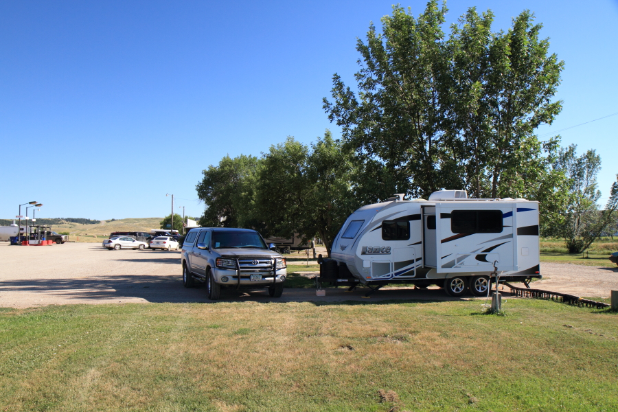
The route from Cache Creek went to Prince George, which I bypassed as I don't like to drive in a big city while pulling the trailer. (I have a Garmin Nuvi navigation system for those times when I can't avoid going through a city, but the one I have doesn't cover Canada or Alaska. However, it's a great thing to have for the areas it does cover.) I then took Canada 16 west, passing though Vanderhoof, which calls itself "the geographical center of British Columbia". Gas is easy to find so far, but I fill up before I get down to half a tank just in case. And I also have an occasional problem with the gas gauge where the needle suddenly goes down to empty, then slowly creeps back up. It would be an expensive fix, so I just keep track of how many miles I've driven on a tank of gas by resetting the trip odometer. Thanks to a recommendation by a friend, I drive to Hazelton and the K'san Campground. The campground has signs along the highway, one reading "Connect With Our Past" then about a half-mile later "Connect With Our Internet". Catchy, but a somewhat incongruous pairing. K'san is a historical village of the Gitxsan First Nation (the Canadian term for Native American) people, and next to the village is the campground. My 2013 Good Sam guide said the campground was Good Sam rated, but the girl at the registration desk said they no longer had that rating. Hmmm...I stayed there anyway. Here's Discovery at K'san Campground, with the Hazelton Mountains as a backdrop --

I found out later when reading the K'san Facebook page that there had been some break-ins and other incidents just within the past few months, so that may have been one of the reasons why they're no longer a Good Sam park. But I had no problems, and the Internet was the best I've had on the trip so far. Just be aware there are no discounts, not even AAA. I walked down to the Skeena River from the campground. The Skeena is the 2nd longest river that is totally within British Columbia, the Fraser being the first. Here the landscape around the Skeena is magnificent in a larger-than-life way; this is the river with the Hazelton Mountains --

In doing some reading on the area The Seven Sisters were mentioned. When I took Tundra out for a day spin the following day, the tops of the mountains were covered in clouds. When I was driving back, I looked in the rear-view mirror and.. there they were ---

They're very rugged, and have been climbed only recently. It's apparently rare to see them so clear, so I'm glad I glanced back. I usually never plan day trips with the Tundra in advance, instead look at my AAA maps and see if one of those roads with the green dots along it are in the area, the green dots meaning scenic. Looking at the map, there was a tiny road going north from the town of Terrace that looked promising, so I took it -- and was glad I did. It was definitely a "a green dot road", with the only drawback being there weren't enough pullouts for picture taking. The route is dominated by Oscar Peak, kind of an odd name for such a magnificent mountain; here's it's mirrored in Lava Lake --

And I used my 100-400 lens for this shot, which foreshortens the distance so it looks closer than it actually is --

The road, Hwy 113, runs through the First Nation land of the Nisga and has quite a few scenic areas, including unique lava beds and a waterfall. It's definitely an area I'd recommend checking out. In fact, as I'm heading back south that way, I may do the drive again, and this time see the places I missed. It's sure nice to be on a flexible schedule...Another example of that happened the next day, when I was heading east on the 16 and saw a blue sign indicating a waterfall. So I parked, took a small walk, and there it was, cascading down the rainforest hillside --

Driving back over to Hazelton you take a bridge over the Skeena River where it meets the Bulkley River. Before the bridge, you get a view of the Skeena looking west, with the Seven Sisters in the distance --

Most Canadian towns, whether big or small, have information centers staffed with people who know the local area. They're a valuable resource that I recommend anyone traveling in Canada to take advantage of. So when I went to Hazelton's VIC I enquired about native totem poles, which are probably the first thing that comes to mind visitors come to the area.

I found it really difficult to photographically capture how impressive and expressive these poles are. But I do like the photo below, which shows the First Nations' traditional belief in contrast to the European religion in the background.

The following day I started on the drive up the Stewart-Cassiar Highway. I'd heard, and read, a lot about it, and was prepared to be impressed with the scenery. And to be honest, I was a bit disappointed. Except for in the Stewart/Hyder area, there are no glaciers. The landscape isn't grand and sweeping, with snow-covered peaks. Instead, it's thickly-forested, "friendly" mountains and lots of charming lakes.

I stayed at Provincial Parks while on the Stewart-Cassiar. They're moderately priced, averaging about $20 Canadian, and are clean and well laid out. But let's go back a few days, August 4, when I stayed at Beaumont Provincial Park, west of Prince George. I nearly forgot to include this incident, and it's one of the pleasures of blogging --- and "Facebooking"-- while on the road. While driving on the entrance road I saw a man and a woman, he carrying a camera and lens like my Canon 7D and 100-400 lens, and she carrying binoculars. As I slowly drove past them I asked "Seen anything good?", meaning birds. The man said "You don't live in Portal, do you?" Uhhh....maybe? How would he know that? Well, he saw my FARANUF license plate, and knew we were Facebook Friends; Len Jellicoe and his wife Dian. When seeing Faranuf, he mentioned he'd been down in Portal and had seen my "street" name, Faranuf Trail. Small world, eh? So after dinner I went over to their campsite and chatted for about an hour. They also had a trailer, so we swapped trailer info. It turned out they had been on the Stewart-Cassiar and were headed home to southwestern British Columbia. And I found out later, when mentioning that I'd met Len, that we had mutual Canadian friends in the birding world. It was another of those accidental meetings that make travel so unpredictable yet fun. And I realized there was no hiding my identity; I may as well have FARANUF written across my forehead. So after that small digression, back to the Stewart-Cassiar...I spent the first night along the road at Kinaskan Lake Provincial Park. It was quite serene and peaceful --

And the next morning's sunrise was a memorable one --

A little bit about the road itself. Being called a highway is a grand name for what it really is -- a two-lane road. There were many "gravel breaks", including one of about 17 kilometers just north of Kinaskan PP. It had rained a bit the night before I drove that section of road, so the dust wasn't as bad as it could have been; the sign at the beginning warned "Extreme Dust". I suppose the best thing about driving the Stewart-Cassiar when I did was that there wasn't much traffic. But the center lines were few and far between, and most of the road had no shoulders, just drop-offs of about 5 feet, so you really couldn't pull over just on a whim. The grades weren't too steep, though, and while there weren't that many rest stops with outhouses, there were "litter pullouts". Here's one of them, at Lower Gnat Lake; Gnat Pass is the highest part of the Stewart-Cassiar, at 1,241 meters, or 3600 feet --

That's the Stewart-Cassiar "Highway" on the right, and this is one of the good paved sections. But again, no center dividing line, and the space can get kinda tight if there's a logging truck roaring on by you. But the landscape was slowly changing to what I'd imagine The Far North to look like --

I spent the last night on the Stewart-Cassiar at Boya Lake. It's popular with the kayaking and canoeing crowd, so there were no spots open on the lake. But I found blissfully-convenient pull through in the upper part of the campground --

Boya Lake is beautiful. When lit by light and the sun, it turns a shade of emerald green, which is caused by the marl on the bottom. When light hits it, the water turns this shade of green. I'll see the same phenomenon at Emerald Lake, near the Yukon's Whitehorse.

While walking along the Boya Lake nature trail, I met Nancy Stevenson, whose husband was a teacher on the Navajo Reservation in northern Arizona. When I mentioned the Chiricahuas, and that I live there, she said they had visited there! Finally, someone who knows the glories of Cave Creek Canyon! Then she mentioned hoodoos, and I knew she was talking about the national monument on the west side. Oh well, at least she'd been to the Chiricahuas, just not on our side -- again. But it was another happy meeting of a fellow traveller.
The next day saw me on the northern section of the Stewart-Cassiar. I stopped at one of the few rest areas, but didn't stay too long once I saw its name -- Rabid Grizzly.

I finally reached the end of the Stewart-Cassiar Highway, and joined the fabled Alaska Highway. I stopped at the corner to get gas. At the few gas stations along the Stewart-Cassiar and Alaska Highways, you either pump then pay, or pay first. I never had any problems running low on gas, and would for the most part fill up the tank before it reached the halfway mark -- and I was lucky to get 10mpg pulling the trailer, so I'd say there's no worries about running out of gas before the next station.

I'm now in the Yukon. Ah, this is more like how I'd imagine The Far North to look: forested landscapes that stretched for miles.

On that day I reached Whitehorse, the largest "town" in the Yukon with a population around 10,000, the largest in the Territory. I pulled into Caribou RV Park, about 20 kilometers outside of town, and ended up spending 5 nights there. My main reason for being there was to re-stock for the first days in Alaska, and a Walmart was conveniently in Whitehorse. But I'm also getting to like dropping the trailer and taking Tundra out for day drives in the area, though they sometimes turn out to be as long as, if not longer, than the drives with Discovery. For instance, take the next day -- I ended up going over 200 miles. I saw a 50-mile drive down to Atlin, the name coming from a First Nation word for "big body of water". It's at the eastern shore of Atlin Lake and is British Columbia's largest natural lake, covering 300 square miles. On the map, and the Milepost guide, which is the "bible" for traveling to Alaska, it's described as about 20 miles of pavement, then gravel the rest of the way. Well, it will be a good test for Tundra for the roads in Alaska. As it turns out, it's been paved all the way through in the past few years. It's very scenic as it goes along the lake. One of the landmarks is Minto Peak, which is high enough to create its own weather. Here the clouds make the mountain look like an erupting volcano --

Alton is the gateway for plane flights into the roadless areas of the Coast Range and the vast Tongass National Forest in the US beyond that. The landscape here is vast and limitless --


I drove back up the road to and connected with the highway to Carcross and Skagway. Between those two towns the scenery looked more like the fjords of Norway, but they're really long, skinny lakes; this is Tagish Lake, 62 miles long and about a mile and a half wide --

And here's Bove Island, in Tagish Lake --

After making a loop of about 200 miles from Whitehorse, I end up a Emerald Lake, another beautiful example, like Boya Lake along the Stewart-Cassiar Highway, of the sun reflecting off the marl at the bottom of the lake, creating the swirls of emerald green. After spending 5 days at Whitehorse, it was now time to move on to the rest of the Yukon portion of the Alaska Highway, and the main reason I drove 6500 miles -- Alaska.