Sunday, January 31, 2016

January 29 --- Khota Circus, Part 2


I'd been to Khota Circus about 2 years ago, and at the time I didn't know where it was, so I spent a lot of that time wandering around, trying to find it. In fact, it may be hard to believe when you see the actual panel below, but I went right past it! But this time I remembered exactly where it was --  


 This main panel is over 90 feet long and is the longest rock art panel in Nevada. It's called a "circus" for the variety of animals represented on it  -- Ants, lizards, snakes, birds, turtles,and others. And it's somewhat unusual among petroglyphs in that it's right at eye level, so you can examine it close up. Here's a closer view of the main panel, though there are still figures out of this view both to the right and left; this is a panorama of 5 photos -- 


The current speculation  is that the area of Khota Circus wasn't a site of human habitation, but rather used for ceremonial purposes; there is a similar area on the other side of the Moapa Valley's Muddy River. And the panel is possibly a scene of mass migration; in the top of the panel the animals are moving to the right, and in the bottom, to the left. 


In the photo below, the figures to the right of the large Desert Bighorn Sheep are lizards, and between them is possibly what is known as a "burden basket", designed by the native peoples to ease the burden of a heavy load. For some reason, it looks like it's upside down -- 


A creature from outer space? No, it's more likely an ant -- 


And though you can't see it, there's a hummingbird off to the left. 

Some of the anthropomorphs (human-like figures) are quite mysterious. What's the meaning of the humanoid figure on the left, with the spiral-like designs coming out of his head? 


I've seen footprint -- and hand -- petroglyphs in other areas like Grand Gulch in southeastern Utah. In my reading online about rock art petroglyphs I've come across some pretty "far-out" ideas for these, and the bottom line is we'll never know for sure -- 


Here's a small animal, possibly a fox -- 


That's a bird's foot on the upper left, and a smaller one to the left of that -- but the human-like figures connected at the hip? --


Here's another possible lizard. I took this photo when the sun was on the panel, so you can see more of the actual pecking and chipping used to create these figures. 


This is probably an eagle -- 


And the animal to the right looks to be a deer; it has a large rack of antler points, where the bighorn sheep have only the 2 horns. But why is the deer figure connected by a line to the spiral? 


Here are a flock of geese, as seen flying in formation -- 


The actual panel of Khota Circus is impressive enough. But on the canyon wall to the right of the Circus, in an area which looks to be nearly inaccessible, are clearest and most precise petroglyph figures that I've ever seen. They literally look as it they were created yesterday -- 


Here's a closer look -- 


And still closer. These photos were taken with my 100-400 lens, essential for viewing the details when they're so high up on the wall.  From what I've read on the Internet, the figures with what looks to be an "H" are more burden baskets, and "H" is a bat clan symbol.  There's also a snake, a reclining flute player (similar to Kokopelli, a universal fertility god) that is above the third basket from the left, crosses with circles, more spirals. It's amazing to see something so old -- at least 500 years or more -- in such pristine condition -- 


On the smaller panel to the left of the main one, there are more sheep, another burden basket with an "H", and more spirals. There is speculation that the burden baskets,when pointed up, means they're full, and there is plenty to eat. When they're pointed down, they're empty, and the tribe goes hungry. Or at least that's one of the theories.. 


The top figure in the next photo is possibly a tree of life, and there's also another anthropomorphic and at cross with spirals at each end -- 


The truth is -- well, we don't know the truth for sure. It may be a story about the journeys that must be made due to the lack of rain, which makes sense in this desert land. Migrations of peoples and sheep, full and empty baskets, flute players representing fertility, creatures seen in the desert -- their exact meaning is mostly speculation. I remember reading somewhere that the mind of the average person living in Europe in the Middle Ages was alien to our way of thinking, because every facet of life back then was based solely around religion in a way that is unfathomable to us. I think the same holds true to the ancient peoples of this area in southern Nevada, indeed in the Southwest; they truly are a "riddle wrapped in a mystery inside an enigma". And perhaps that's the way it should be... 


Saturday, January 30, 2016

January 29 -- I Return To Khota Circus (Part One)

There was so much to see that I have to divide the day up into 2 separate posts, possibly 3...I'd been to Khota Circus before, nearly 2 years ago. It's an astounding place, but the journey to get there was nearly as memorable. I left Overton around 6:15am as it's about a 65-mile drive over paved and 4-wheel-drive dirt roads, and I didn't know what condition they'd be in. As I drove north along the main road through the Moapa Valley, I could see the sky to the east was going to give a terrific dawn display. So of course I ended up behind a school bus. Luckily, it only stopped once to pick up kids, but it looks bad if you pass one at all, so there was quite a procession of (mostly) trucks behind it before it pulled off to the side to head back down the valley. I got on the interstate and stopped at a truck parking turnout in time to see the sunrise colors over the Virgin Mountains,  my destination for the day -- 


Now THAT is a good omen. I looked off to the north and saw the tops of the Mormon Mountains were being it by the sunlight, so I pulled off at the next offramp (to Carp and Elgin, via a tiny dirt road) to get some photos, first with the 17-55 f/2.8 landscape lens -- 


Then with the 100-400 f/5.6 lens, zooming in on the main peak --


Boy, this was starting out to be a great day trip!  The actual road to Gold Butte starts of by passing some ranching areas -- including one that has a sign reading "Bundy's Melons"; yes, it's THAT Bundy. There are other signs along the potholed, uneven and sometimes dusty road, some at bit more humorous --


Let's hope that doesn't happen to me as it's a long way back into town... I pass a road veering off to the west, which goes down to one of the north arms of Lake Mead (the other, Overton Arm, dried up when the reservoir's water receded due to the drought). You can see Lake Mead, and the north shore of the national recreation area --


Gold Butte is only about 30 miles air distance from Overton, but you have to drive around 60 miles to get there. The Virgin Mountains' Virgin Peak is 8,075 feet high --


And the road to Gold Butte heads south, both roller-coastered and potholed --


The road I take to begin the hike to Khota Circus isn't as bad as I thought, but you still have to take it VERY slow unless you want to sail over the small, narrow washes and break an axle. There's one old guy parked in a battered red truck; he must've spent the night there as he was airing out his sleeping bag. Hmmm, I was hoping I'd be alone during my hike -- I am.

The setting moon over Gold Butte. 


All of southern Nevada and the tip of southwestern Utah are in the driest of all the North American deserts, the Mojave. Joshua Trees, named by Mormon settlers because their shape reminded them of a story where Joshua reaches his hands up to the sky in prayer,  are what's known as an "indicator species" for the Mojave. They can live for hundreds of years; they're scattered here and there in this landscape. With the clouds (which do wonders all day) and multi-colored rock, the scenery is dramatic and beautiful.


Like my recent visit to Buffington Pockets, it's as quiet as a church mouse -- or as quiet as the grave. There's not even the slightest breeze. And though I see animal tracks -- lizards, mice, coyote -- I only see a single lizard the entire time I'm out here.


The Gold Butte area, south of Mesquite, is 350,000 acres of spectacular, wild, and remote scenery.  The area has a history of mining -- the town of Gold Butte had a population of 1,000 at one time -- but the total takeout in the district has only been $75,000, and no significant deposits have been found. In current years, it's seen battles over its status: protected or unprotected? All or part?
It's a focal point of the "Sagebrush Rebellion". These things and more are going through my mind as I make my way to Khota Circus.


To be continued...

Friday, January 29, 2016

January 27 -- A Short Stay At The OWMA, And Buffington Pockets


January 27 -- as 27 is an odd number, and hunting is on even days, I decided to take another morning ramble through the Overton Wildlife Management Area. I went to the "upper" parking lot, and on the way there saw a Verdin and a Black-tailed Gnatcatcher, both right out in the open. I took photos of both, then realized I hadn't cleared off the memory card in the camera though I'd downloaded the photos on it to my external hard drive. So I reformatted the card, deleting all of the photos -- including the ones I just took of the Verdin and Gnatcatcher. Curses!  That was the first time I'd seen a Verdin during this winter stay at Overton; how lucky would I be see another one? Well, as it turns out, either the same one, or another one, popped up on a branch a little further down the road. Thinking back on it, I'd played a Verdin call on my "smart phone" after I'd seen the one, and thought it didn't work as there was no response; he must have heard it, and was looking around to investigate in a different spot. So I got my Verdin pic... 


I parked at the lot, and saw another car there. I thought it was unusual, as I'm usually the only one there on non-hunting days during the week. However, when I was walking up the road, a fellow in camouflage and a red vest was walking towards me, with a rifle slung over his shoulder. Oh oh... Is it the 28th? Did I get the day wrong? And he had his daughter with him, who must have been all of 4 years old. He was holding her hand, with a rifle slung over his shoulder. The whole scene just looked a little bit bizarre. But what got me really wondering was why he was there. So I kept walking, and saw the Mr. and Mrs. Red-tailed Hawk who reside at the tall trees near the upper parking lot. They're beautiful birds; here's the male -- 


And here's the female -- a dark morph. I've seen her in that area for the past 3 winters, and I know she's a female because she's much larger than her mate; I've seen them side by side.


After I said hello to the Red-tail couple, I saw a flock of birds flying in formation. I looked through my binoculars -- and they were either Snow or Ross's Geese --


Chances are they were Snow Geese and Ross's are rarer for this area. And when the geese landed in a pond, and I was able to get a closer look at them, I saw they had the "grinning patch", where it looks as if they're, well, grinning. Ross's Geese don't have that.


I walked further into the wildlife area -- and saw another guy in a red vest, holding a rifle. Hmmm... OK, it's time to leave. Especially after I heard gunfire. As I reached the parking lot, the fellow I'd seen first was at this car with another man, and I asked "Is there hunting going on today?" One of them said "Yes, rabbit and quail." Oops, I'm outta here. There are days set aside for hunting specific birds and animals -- quail, doves, rabbits, etc. -- and I happened to stumble into one. So, as it was only 9am, where can I go that's fairly close? Then I thought -- Buffington Pockets.

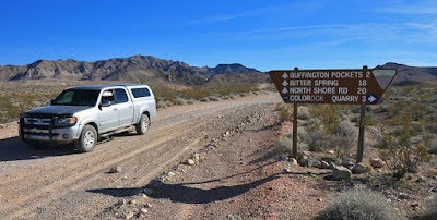
It's near the Valley of Fire, and has been described as a geologic wonderland, a description that fits pretty much most of this area of SE Nevada. The access road is a good one, wide and not much "washboarding", though there are occasional spots of sand. The Old Spanish Trail, which as we've seen crossed over the Moapa Valley's Mormon Mesa, also went through here, and one of the roads crossing this one is the route of the actual trail. At an intersection, the BLM has put up a sign so you know you're heading in the right direction  --


(This and the previous photo were taken as I was coming out of Buffington Pockets; it's actually behind me. I take a right off the byway and end up on a pretty rough "road" that turns into a rocky wash. Hmmm, maybe this wasn't the right turnoff...So I stop at an area with a fire ring, park, and head up the wash.


The rutted, rocky road goes up through a narrow canyon. No "pockets" here, I say to myself. Then I turn the corner up ahead --


And there is Huffington Pockets -- towering, sculpted sand formations. It's in the Muddy Mountains, and, as Brian Beffort writes in his guidebook to the Southern Nevada area, it's a spot  " where Jurassic-area...sandstone meets much older Pre-Cambrian limestone, often in amazing and beautiful ways." And he's right. It may not be as spectacular as the nearby Valley of Fire, but it's compact and, as is the case with many places here in SE Nevada during a winter weekday, blissfully quiet and empty --


There's a dirt road that winds through here, so that provides easy walking. I look off to my right, and see a surprising thing in this desert, pockets of water --


What a beautiful, totally unexpected sight to see here. It makes for a unique contrast to the rocky landscape --

But where the heck did the water come from? I see something even MORE surprising to be out in the middle of "nowhere" -- a dam. 


Who built this, and why? For mining? I consider climbing up the rocky incline in the center of the photo, but listen to "the little man" and decide against it. That's all I need to do out here, slip down and break something --


It's just totally unexpected, and utterly gorgeous. Here's an example of the dark Pre-Cambrian limestone meeting the Jurassic sandstone --


Looking back to the west, with the Sheep Range in the distance --


Eroded sandstone formations are very reminiscent of the Valley of Fire. And evidence of ancient peoples have been found here, so I'm using my binoculars to to peer up at sections of the rock that may have some petroglyphs. There are many candidates among the flat, darker rock --


The road climbs up and out of the main area of Buffington Pockets. (I actually turned off the main road too early; if I had kept on going, I would have come across this road and taken it in other direction than I was walking, going west.)  As you get higher, the views get more expansive --


And once again, you need a panorama to get an idea of the wide-open spaces here. The main area of Buffington Pockets lies below the flat area running lengthwise along this photo --


Here's a closeup of the area --


I am lucky to have clouds this day. They really add to the already spectacular landscape, as with this sandstone formation --


Another view of Buffington Pockets; you can see the road going through the pockets to the right --


I retrace my steps back. There are some things I missed , such as this. I certainly hope whoever was doing this "target practice" didn't destroy a petroglyph panel. I examine the wall carefully, and it looks like there's contemporary graffiti scrawled on it --


As I walk back to Tundra, I see a sandstone arch off in the distance --


And one closer, on the other side of the road --


It's weird how these things work out, but it seems like there was a reason why it was meant for me to come out here instead of the wildlife area in Overton. And I get back in time for a gorgeous sunset, with the wildlife area's Honeybee Pond like a golden-hued river --


This land of SE Nevada is full of wonderful surprises..