Rain is a pretty rare event here in SE Nevada. But with the current El Nino weather pattern, it's inevitable that we get some. And while it didn't rain too much down here in the Overton and the Moapa Valley, it rained a good deal up at the Valley of Fire, where it matters for photographers. Well, it did rain somewhat here in the valley; this is a photo of the RV park where I'm staying, the morning after the heaviest rain --

That's running water down the center of the road. It looks worse than it was; it dried up later in the morning. But rain here meant rain up top, at the Valley of Fire -- and it didn't disappoint. In fact, I went to the VOF for the next 3 days, to take advantage not only of the water collecting in the depressions in the rock, but the snowy backgrounds; the snow level was down to around 3500 feet. On the 6th, as I arrived at the east entrance of the park, the clouds were cloaking the mountains, but my attention was caught by this sign --

Literally a sign of the times. Was this a problem here, at a fairly remote park? A friend of mine saw this photo and said the park has jurisdiction over the land, while the FAA has control of the air space above, and this leads to some conflict and confusion as to who's responsible for the "friendly skies". Whoever is in charge, it really gets your attention as you enter the park.
Let me backtrack for a moment. I actually took a short drive in the Lake Mead National Recreation Area and Northshore Road, which runs along the north shore of the "lake". It's a favorite drive of mine, with its multicolored hills and desert vistas. Here's a view looking across Lake Mead, which you can see at the bottom. It's still raining, but the sun is breaking through the clouds --

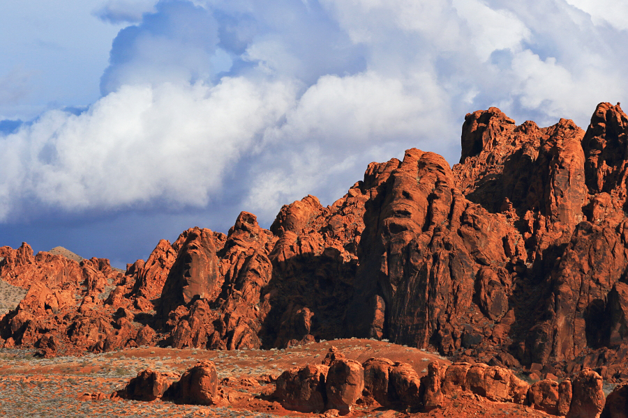
Like cotton candy, or cotton balls pulled apart. (And when I posted this on Facebook, someone mentioned seeing a face in the rock on the right; it's looking up, somewhat like an Easter Island statue -- and they're right. Lots of human and animal forms can be seen in the rocks here.) On the loop road near the campground, there's a somewhat famous landmark called Piano Rock --

With 2 legs, it's like a massive Steinway. Back past the visitor center, I look across to the area of Piano Rock in the distance --

The rains were on the 5th thru 7th. On the 8th, a rare event happened -- the White Domes Scenic Byway, leading to the north end of the park, was closed. The ranger said mud had covered the roadway, so it was being cleaned up and scheduled to re-open in a hour or so. Still, I had to take a photo as it's something you don't see here too often.

I had some time to kill, so I looked for a particular image in the rock near the visitor center. If you look closely and know your iconic images of the 20th century, you may recognize this one --

It's been called a redrock version of Edvard Munch's painting "The Scream" (yes, this was before that kid clapped his hands to his face in "Home Alone"). With just a little imagination, you can see hundreds of images in the Valley of Fire rocks. A little later the road re-opened, and as I entered the narrow defile leading to the north end of the park, I could see what the ranger was talking about --


The low winter sun was illuminating the landscape, but the sky to the north still looked ominous. And I thought the sinuous road added interest to the overall scene --

There are 3 parking lots along the White Domes Byway. There are No Parking signs all along the sides of the road; you can only park in the lots as much of the road is narrow and twisty. From the lots, you can hike to your heart's content. I hiked west from parking lot #3; hiking east leads to the Fire Wave. To the west is more interesting. There's the massive monolith with its near-vertical face that somewhat reminds me of Half Dome --

Long ago, that rock face must've fallen right off, creating that jumble of rock at the bottom --

Here's an overall view of that area, looking northeast from atop a nearby hill --

There's a unique formation down there called Crazy Hill -- though many formations here can be called that --

It's striped, colorful rock that grows more intense depending on the angle of light and clouds. It wasn't too bad today -- and when I was there a lone hiker was on top of a nearby dome, silhouetted against the sky --

Here's looking up at that face of Crazy Hill --

This is near the area of "The Swoosh", where a pattern in the rock resembles the Nike logo. See that small "arch" on top of that rock near the center?

The Valley of Fire rewards you with many small details.. Here's looking east near the same location; the mountain wreathed in clouds is Virgin Peak, tallest in the Virgin Mountains --

This area is among the most colorful in the park --


Back out of the park and on the highway to Overton, you can get an even better view of Virgin Peak --- if you have a 100-400 lens, that is, which is what I used to take this photo --

As I mentioned earlier, the snow level was down to around 3500 feet, so it was a treat to see the desert mountains here dusted with snow; this is looking at the Gold Butte area, land of Falling Man, Little Finland and Khota Circus --

When I was going through the "boon docker's mesa" just south of Overton, a massive thunderstorm was forming to the northeast. It dwarfed the houses of Overton below it; the long mesa is called Mormon Mesa; Mormons were the original settlers here, and Overton is still a Mormon community --

It was an exciting 3 days packed with colorful landscapes tempestuous weather, and rarely seen snowy vistas. Tomorrow it's back to the wildlife management area here..
No comments:
Post a Comment